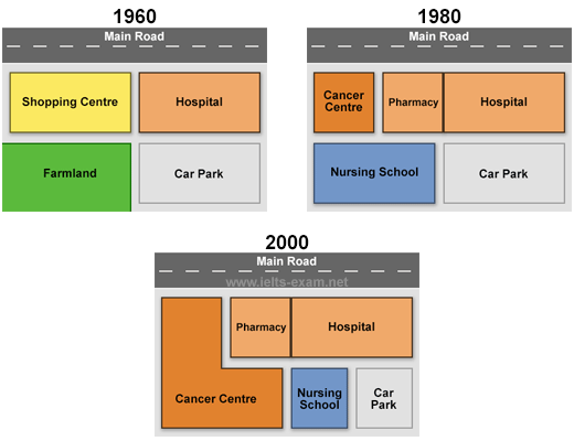
The three maps depict the development(evolution) of Queen Marry Hospital over a 40-year period, from 1960 to 2000.
Overall, it is evident that the hospital was expanded to serve more patients. The most notable changes were the replacement of shopping center by cancer center and the reduction in the size of the car park.
According to the first map in 1960, Queen Marry Hospital was situated beside the main road and was mainly divided into four major areas: a shopping center, the hospital itself, a farmland, and a large car park. While the Shopping center covered the right, the Hospital occupied the left part. Additionally, behind the shopping center lay a large farmland, and the car park extended behind the hospital..
By 1980, the hospital had initiated a phase of expansion, during which the shopping center and the farmland located behind it were replaced by the introduction of cancer center, a pharmacy, and a nursing school. By 2000, the cancer center was further enlarged, encroaching on part of the nursing school. To accommodate these developments, the size of the car park was reduced in both periods.