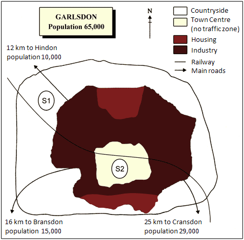
The map presents two possible locations, S1 and S2, for a new supermarket in the town of Garlsdon. The most notable distinction between them is that S1 is situated on the outskirts of the town, while S2 is located in the town centre. They also differ in terms of road and rail accessibility, as well as their proximity to three neighbouring towns.
Examining the details, S1 lies in the countryside to the north-west of Garlsdon, though it is still relatively close to the town’s residential area. Similarly, S2 is positioned near housing, which encircles the central area.
Garlsdon is connected to the nearby towns of Hindon, Bransdon, and Cransdon by main roads. However, the town centre is designated as a no-traffic zone, meaning that S2 could not be reached directly by car. In contrast, S1 is located on the main road to Hindon, making access easier for residents there, though less straightforward for those travelling from Bransdon or Cransdon. Both proposed sites are conveniently located near the railway line that links Hindon and Cransdon, passing through Garlsdon.