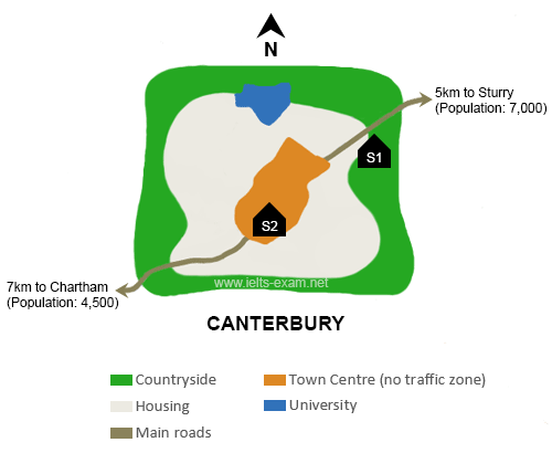
The map illustrates two potential locations for a new school to serve the town of Canterbury and its surrounding area.
The first proposed site (S1) lies in the countryside to the north-east of the town centre, just beyond the main residential zone. Its proximity to the road connecting Sturry with Canterbury makes it particularly convenient for students travelling from Sturry, which is only 5 kilometres away, as well as for those living on Canterbury’s eastern side. Pupils coming from Chartham, situated 7 kilometres to the south-west, could also access the school easily via the main road running in that direction.
In contrast, the second option (S2) is located in the heart of the town. This central position would place it at roughly equal distance from both Sturry and Chartham, making it equally accessible for students from either settlement. It would also be highly convenient for those living in the surrounding urban residential area. However, the town centre’s pedestrian-only zone would prevent parents from driving directly to the school gates, which might pose challenges for families who rely on car transport.